Atescatempa night lights from space
Night Light of Atescatempa (Jutiapa) from space (Guatemala) Src. Average luminocity for 10x10km area is 2.1429% and for 50x50km: 4.6167%.
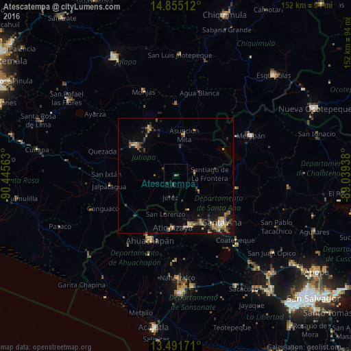
Analysis of Atescatempa night lights 2016
Square area 10x10 km:
 0%
0%90-99
0%80-89
0%70-79
0%60-69
0.87%50-59
0%40-49
1.08%30-39
1.52%20-29
0.87%10-19
0%0-9
95.67%Square area 50x50 km:
0.09%90-99
0.28%80-89
0.86%70-79
0.72%60-69
0.73%50-59
0.88%40-49
0.83%30-39
1.06%20-29
1.01%10-19
3.01%0-9
90.52%Clear (daylight) street map image can be seen on geolist.org.
Map coordinates:
14° 51' 18.4" North, 90° 26' 44.3" West
14° 10' 28" North, 89° 44' 33" West
13° 29' 30.2" North, 89° 2' 21.8" West
Some cities around Atescatempa sort by population:
• Santa Ana, SV
28.1 km =17.5 mi,  135°
135°
• Jutiapa
21 km =13 mi,  308°
308°
• Chalchuapa, SV
21.9 km =13.6 mi,  162°
162°
• Asunción Mita
17.7 km =11 mi,  11°
11°
• Jalpatagua
28.9 km =18 mi,  262°
262°
• Atiquizaya, SV
22 km =13.7 mi,  182°
182°
• El Progreso
22.7 km =14.1 mi,  329°
329°
• Candelaria de La Frontera, SV
11.9 km =7.4 mi,  122°
122°
3599633 (p: 11,543)
Sources (retrieved 2019-11-25):
» Earth at Night: Flat Maps 2012, 2016