San José Acatempa night lights from space
Night Light of San José Acatempa (Jutiapa) from space (Guatemala) Src. Average luminocity for 10x10km area is 0.0173% and for 50x50km: 1.1842%.
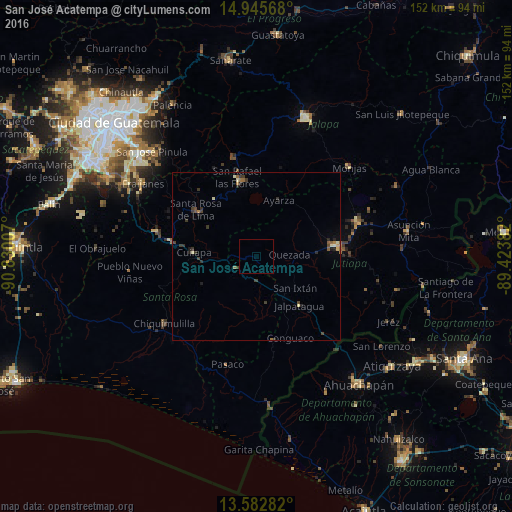
Analysis of San José Acatempa night lights 2016
Square area 10x10 km:
 0%
0%90-99
0%80-89
0%70-79
0%60-69
0%50-59
0%40-49
0%30-39
0%20-29
0%10-19
0%0-9
100%Square area 50x50 km:
0%90-99
0.13%80-89
0.17%70-79
0.05%60-69
0.25%50-59
0.19%40-49
0.26%30-39
0.49%20-29
0.39%10-19
0.15%0-9
97.91%Clear (daylight) street map image can be seen on geolist.org.
Map coordinates:
14° 56' 44.4" North, 90° 49' 48.3" West
14° 15' 55" North, 90° 7' 37" West
13° 34' 58.2" North, 89° 25' 25.8" West
Some cities around San José Acatempa sort by population:
• Jutiapa
25.1 km =15.6 mi,  83°
83°
• Cuilapa
18.6 km =11.6 mi,  273°
273°
• Jalpatagua
18.8 km =11.7 mi,  137°
137°
• Oratorio
6.7 km =4.2 mi,  231°
231°
• Nueva Santa Rosa
20.6 km =12.8 mi,  308°
308°
• Casillas
21.2 km =13.2 mi,  323°
323°
• Moyuta
25.7 km =16 mi,  168°
168°
• Santa Rosa de Lima
22.7 km =14.1 mi, 306°
3590053 (p: 6,367)
Sources (retrieved 2019-11-25):
» Earth at Night: Flat Maps 2012, 2016