Champerico night lights from space
Night Light of Champerico (Retalhuleu) from space (Guatemala) Src. Average luminocity for 10x10km area is 3.9199% and for 50x50km: 0.2865%.
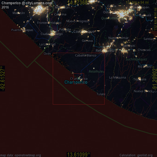
Analysis of Champerico night lights 2016
Square area 10x10 km:
 0%
0%90-99
0%80-89
0.87%70-79
0.87%60-69
1.73%50-59
0.43%40-49
1.3%30-39
0%20-29
0.87%10-19
0%0-9
93.94%Square area 50x50 km:
0%90-99
0.03%80-89
0.04%70-79
0.03%60-69
0.07%50-59
0.03%40-49
0.08%30-39
0.02%20-29
0.08%10-19
0.17%0-9
99.45%Clear (daylight) street map image can be seen on geolist.org.
Map coordinates:
14° 58' 25.2" North, 92° 36' 55" West
14° 17' 36.1" North, 91° 54' 43.7" West
13° 36' 39.6" North, 91° 12' 32.5" West
Some cities around Champerico sort by population:
• Retalhuleu
37 km =23 mi,  43°
43°
• Nuevo San Carlos
40.8 km =25.4 mi, 35°
• San Sebastián
41.2 km =25.6 mi, 43°
• Brisas Barra de Suchiate, MX
43.1 km =26.8 mi,  308°
308°
• Flores Costa Cuca
38.1 km =23.7 mi,  7°
7°
• Cuyotenango
45.8 km =28.5 mi,  53°
53°
• Ocós
38.7 km =24 mi, 308°
• El Asintal
39.1 km =24.3 mi,  30°
30°
3598787 (p: 7,761)
Sources (retrieved 2019-11-25):
» Earth at Night: Flat Maps 2012, 2016