Préveza night lights from space
Night Light of Préveza (Epirus) from space (Greece) Src. Average luminocity for 10x10km area is 24.7581% and for 50x50km: 5.8172%.
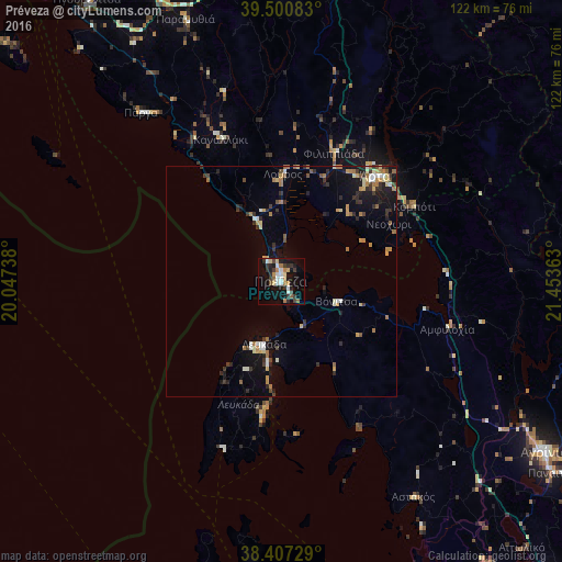
Analysis of Préveza night lights 2016
Square area 10x10 km:
 2.92%
2.92%90-99
4.38%80-89
2.44%70-79
3.41%60-69
3.08%50-59
2.11%40-49
2.44%30-39
6.17%20-29
3.73%10-19
23.7%0-9
45.62%Square area 50x50 km:
0.38%90-99
0.81%80-89
0.68%70-79
0.85%60-69
1.05%50-59
0.45%40-49
0.58%30-39
1.18%20-29
1.22%10-19
4.25%0-9
88.57%Clear (daylight) street map image can be seen on geolist.org.
Map coordinates:
39° 30' 3" North, 20° 2' 50.6" East
38° 57' 22.2" North, 20° 45' 1.8" East
38° 24' 26.2" North, 21° 27' 13.1" East
Some cities around Préveza sort by population:
• Ioánnina
79.3 km =49.3 mi,  6°
6°
• Agrínio
68 km =42.3 mi,  123°
123°
• Árta
30.4 km =18.9 mi,  41°
41°
• Mesolóngi
87.9 km =54.6 mi,  137°
137°
• Anatolí
76.2 km =47.3 mi, 7°
• Igoumenítsa
73.7 km =45.8 mi,  325°
325°
• Lefkáda
14.5 km =9 mi,  195°
195°
• Áyios Konstandínos
66.7 km =41.4 mi, 122°
254698 (p: 17,283)
Sources (retrieved 2019-11-25):
» Earth at Night: Flat Maps 2012, 2016