Lefkáda night lights from space
Night Light of Lefkáda (Ionian Islands) from space (Greece) Src. Average luminocity for 10x10km area is 20.5272% and for 50x50km: 3.5628%.
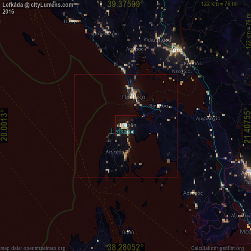
Analysis of Lefkáda night lights 2016
Square area 10x10 km:
 2.72%
2.72%90-99
5.44%80-89
2.21%70-79
1.19%60-69
3.4%50-59
0.34%40-49
1.87%30-39
2.55%20-29
1.19%10-19
21.43%0-9
57.65%Square area 50x50 km:
0.26%90-99
0.61%80-89
0.28%70-79
0.54%60-69
0.43%50-59
0.27%40-49
0.47%30-39
0.72%20-29
0.63%10-19
2.41%0-9
93.38%Clear (daylight) street map image can be seen on geolist.org.
Map coordinates:
39° 22' 33.6" North, 20° 0' 4.7" East
38° 49' 49.3" North, 20° 42' 15.9" East
38° 16' 49.9" North, 21° 24' 27.2" East
Some cities around Lefkáda sort by population:
• Agrínio
65.3 km =40.6 mi,  110°
110°
• Árta
44 km =27.3 mi,  33°
33°
• Préveza
14.5 km =9 mi,  15°
15°
• Mesolóngi
81.2 km =50.5 mi,  128°
128°
• Argostólion
74.6 km =46.4 mi,  194°
194°
• Anatolí
90.6 km =56.3 mi,  8°
8°
• Igoumenítsa
83.8 km =52.1 mi,  333°
333°
• Áyios Konstandínos
64.1 km =39.8 mi, 109°
258438 (p: 8,673)
Sources (retrieved 2019-11-25):
» Earth at Night: Flat Maps 2012, 2016