Panórama night lights from space
Night Light of Panórama (Central Macedonia) from space (Greece) Src. Average luminocity for 10x10km area is 59.3896% and for 50x50km: 20.5224%.
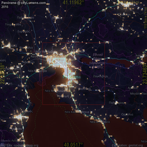
Analysis of Panórama night lights 2016
Square area 10x10 km:
 14.12%
90-99
18.99%80-89
5.84%70-79
5.19%60-69
7.47%50-59
5.36%40-49
6.01%30-39
8.6%20-29
9.25%10-19
17.69%0-9
1.46%Square area 50x50 km:
3.98%90-99
4.39%80-89
1.92%70-79
2.05%60-69
2.89%50-59
2.12%40-49
2.46%30-39
3.62%20-29
5.92%10-19
10.22%0-9
60.43%Clear (daylight) street map image can be seen on geolist.org.
Map coordinates:
41° 7' 10.6" North, 22° 19' 42.2" East
40° 35' 16" North, 23° 1' 53.4" East
40° 3' 6.1" North, 23° 44' 4.7" East
Some cities around Panórama sort by population:
• Thessaloníki
10.5 km =6.5 mi,  306°
306°
• Kalamariá
6.9 km =4.3 mi,  265°
265°
• Sykiés
9.7 km =6 mi,  315°
315°
• Pylaía
4 km =2.5 mi,  288°
288°
• Thérmi
4.6 km =2.9 mi,  192°
192°
• Triandría
5.6 km =3.5 mi,  302°
302°
• Ágios Pávlos
8.4 km =5.2 mi, 314°
• Asvestochóri
6 km =3.7 mi,  354°
354°
734771 (p: 16,551)
Sources (retrieved 2019-11-25):
» Earth at Night: Flat Maps 2012, 2016