Palamás night lights from space
Night Light of Palamás (Thessaly) from space (Greece) Src. Average luminocity for 10x10km area is 15.6854% and for 50x50km: 8.0244%.
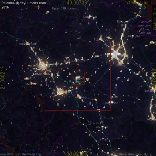
Analysis of Palamás night lights 2016
Square area 10x10 km:
 0.34%
0.34%90-99
3.23%80-89
1.53%70-79
0.68%60-69
5.1%50-59
0.34%40-49
0.85%30-39
3.91%20-29
2.04%10-19
3.4%0-9
78.57%Square area 50x50 km:
0.22%90-99
1.43%80-89
0.93%70-79
0.77%60-69
1.25%50-59
0.86%40-49
0.98%30-39
1.42%20-29
1.69%10-19
5.47%0-9
84.97%Clear (daylight) street map image can be seen on geolist.org.
Map coordinates:
40° 0' 26.5" North, 21° 22' 48.8" East
39° 28' 0" North, 22° 4' 60" East
38° 55' 18.3" North, 22° 47' 11.3" East
Some cities around Palamás sort by population:
• Lárisa
34.3 km =21.3 mi,  56°
56°
• Tríkala
28.7 km =17.8 mi,  289°
289°
• Kardítsa
17.9 km =11.1 mi,  230°
230°
• Týrnavos
34.9 km =21.7 mi,  30°
30°
• Fársala
32.2 km =20 mi,  126°
126°
• Kalampáka
47.2 km =29.3 mi,  304°
304°
• Giánnouli
34.9 km =21.7 mi,  50°
50°
• Ampelóna
39.3 km =24.4 mi,  38°
38°
256047 (p: 5,719)
Sources (retrieved 2019-11-25):
» Earth at Night: Flat Maps 2012, 2016