Týrnavos night lights from space
Night Light of Týrnavos (Thessaly) from space (Greece) Src. Average luminocity for 10x10km area is 12.2922% and for 50x50km: 9.0069%.
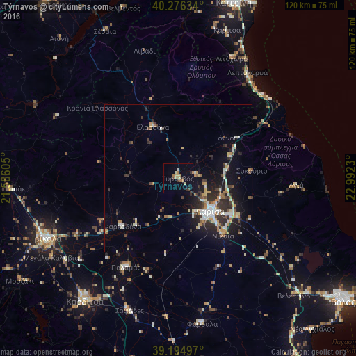
Analysis of Týrnavos night lights 2016
Square area 10x10 km:
 0.16%
0.16%90-99
1.3%80-89
2.92%70-79
0.49%60-69
3.9%50-59
0%40-49
1.3%30-39
2.44%20-29
1.14%10-19
2.76%0-9
83.6%Square area 50x50 km:
0.8%90-99
1.9%80-89
0.97%70-79
1.05%60-69
1.1%50-59
0.67%40-49
0.87%30-39
1.83%20-29
2.9%10-19
5.88%0-9
82.03%Clear (daylight) street map image can be seen on geolist.org.
Map coordinates:
40° 16' 34.8" North, 21° 35' 9.8" East
39° 44' 16" North, 22° 17' 21" East
39° 11' 41.9" North, 22° 59' 32.3" East
Some cities around Týrnavos sort by population:
• Lárisa
15.7 km =9.8 mi,  135°
135°
• Tríkala
49 km =30.4 mi,  245°
245°
• Fársala
49.9 km =31 mi,  170°
170°
• Giánnouli
12 km =7.5 mi,  130°
130°
• Elassóna
19.4 km =12.1 mi,  333°
333°
• Litóchoro
44.1 km =27.4 mi,  23°
23°
• Ampelóna
6.6 km =4.1 mi,  83°
83°
• Palamás
34.9 km =21.7 mi,  210°
210°
252848 (p: 10,796)
Sources (retrieved 2019-11-25):
» Earth at Night: Flat Maps 2012, 2016