Karpenísi night lights from space
Night Light of Karpenísi (Central Greece) from space (Greece) Src. Average luminocity for 10x10km area is 5.2636% and for 50x50km: 0.6397%.
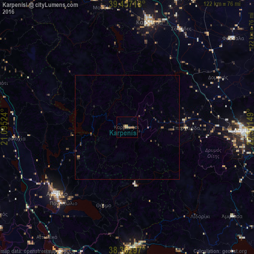
Analysis of Karpenísi night lights 2016
Square area 10x10 km:
 0%
0%90-99
0%80-89
0.51%70-79
1.19%60-69
2.55%50-59
1.19%40-49
0.68%30-39
0.85%20-29
1.19%10-19
0%0-9
91.84%Square area 50x50 km:
0%90-99
0%80-89
0.02%70-79
0.07%60-69
0.19%50-59
0.12%40-49
0.23%30-39
0.24%20-29
0.3%10-19
0.1%0-9
98.73%Clear (daylight) street map image can be seen on geolist.org.
Map coordinates:
39° 27' 25.8" North, 21° 5' 42.9" East
38° 54' 43.8" North, 21° 47' 54.1" East
38° 21' 46.7" North, 22° 30' 5.4" East
Some cities around Karpenísi sort by population:
• Lamía
55 km =34.2 mi,  91°
91°
• Agrínio
46.8 km =29.1 mi,  226°
226°
• Kardítsa
51.4 km =31.9 mi,  11°
11°
• Náfpaktos
57.9 km =36 mi,  177°
177°
• Fársala
66.1 km =41.1 mi,  49°
49°
• Ámfissa
65.9 km =40.9 mi,  130°
130°
• Áyios Konstandínos
46.4 km =28.8 mi, 228°
• Palamás
66.4 km =41.3 mi,  21°
21°
260891 (p: 6,888)
Sources (retrieved 2019-11-25):
» Earth at Night: Flat Maps 2012, 2016