Kryonéri night lights from space
Night Light of Kryonéri (Attica) from space (Greece) Src. Average luminocity for 10x10km area is 63.6667% and for 50x50km: 41.2783%.
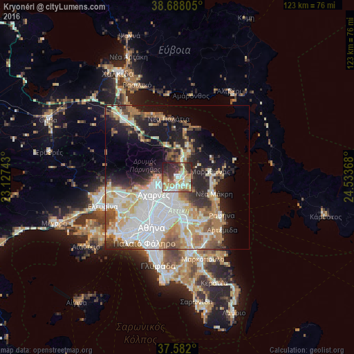
Analysis of Kryonéri night lights 2016
Square area 10x10 km:
 8.67%
8.67%90-99
15.31%80-89
15.48%70-79
10.03%60-69
8.5%50-59
4.76%40-49
7.82%30-39
11.39%20-29
15.99%10-19
2.04%0-9
0%Square area 50x50 km:
11.78%90-99
9.12%80-89
4.37%70-79
5.44%60-69
5.77%50-59
3.81%40-49
3.77%30-39
4.04%20-29
7.46%10-19
11.84%0-9
32.6%Clear (daylight) street map image can be seen on geolist.org.
Map coordinates:
38° 41' 17" North, 23° 7' 38.7" East
38° 8' 13.6" North, 23° 49' 50" East
37° 34' 55.2" North, 24° 32' 1.2" East
Some cities around Kryonéri sort by population:
• Kifisiá
7.2 km =4.5 mi,  193°
193°
• Néa Erythraía
5 km =3.1 mi, 188°
• Ágios Stéfanos
2.5 km =1.6 mi,  64°
64°
• Drosiá
3.5 km =2.2 mi,  123°
123°
• Anoixi
2.5 km =1.6 mi,  101°
101°
• Thrakomakedónes
6.4 km =4 mi,  262°
262°
• Ekáli
3 km =1.9 mi,  172°
172°
• Diónysos
5.6 km =3.5 mi,  130°
130°
258793 (p: 5,040)
Sources (retrieved 2019-11-25):
» Earth at Night: Flat Maps 2012, 2016