Ágios Stéfanos night lights from space
Night Light of Ágios Stéfanos (Attica) from space (Greece) Src. Average luminocity for 10x10km area is 56.131% and for 50x50km: 38.9223%.
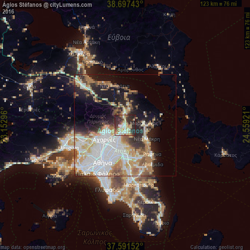
Analysis of Ágios Stéfanos night lights 2016
Square area 10x10 km:
 5.27%
5.27%90-99
14.46%80-89
12.76%70-79
5.95%60-69
7.65%50-59
3.57%40-49
7.65%30-39
13.78%20-29
26.7%10-19
2.21%0-9
0%Square area 50x50 km:
11.4%90-99
8.61%80-89
4.05%70-79
5.15%60-69
5.55%50-59
3.31%40-49
3.09%30-39
3.57%20-29
7.12%10-19
11.48%0-9
36.64%Clear (daylight) street map image can be seen on geolist.org.
Map coordinates:
38° 41' 50.7" North, 23° 9' 10.7" East
38° 8' 47.7" North, 23° 51' 21.9" East
37° 35' 29.5" North, 24° 33' 33.2" East
Some cities around Ágios Stéfanos sort by population:
• Kifisiá
8.9 km =5.5 mi,  206°
206°
• Néa Erythraía
6.7 km =4.2 mi, 206°
• Drosiá
3.1 km =1.9 mi,  166°
166°
• Anoixi
1.6 km =1 mi, 171°
• Thrakomakedónes
8.8 km =5.5 mi,  257°
257°
• Ekáli
4.4 km =2.7 mi,  204°
204°
• Diónysos
5.1 km =3.2 mi,  156°
156°
• Kryonéri
2.5 km =1.6 mi,  244°
244°
263725 (p: 9,892)
Sources (retrieved 2019-11-25):
» Earth at Night: Flat Maps 2012, 2016