Áno Liósia night lights from space
Night Light of Áno Liósia (Attica) from space (Greece) Src. Average luminocity for 10x10km area is 85.0649% and for 50x50km: 46.7266%.
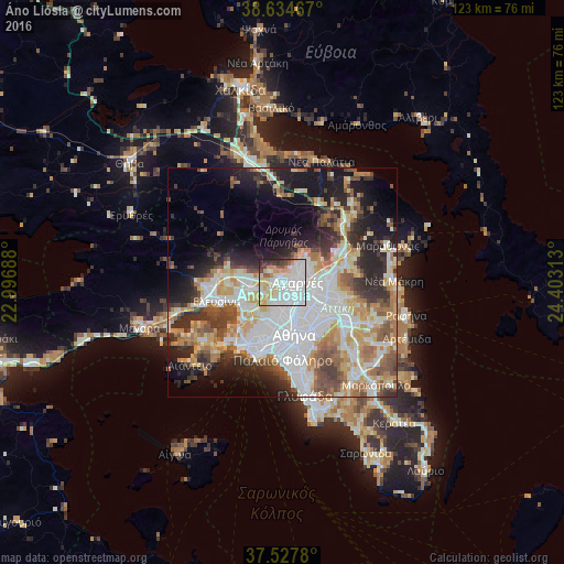

Analysis of Áno Liósia night lights 2016
Square area 10x10 km:
 40.91%
90-99
20.78%80-89
9.25%70-79
11.53%60-69
2.76%50-59
3.57%40-49
3.9%30-39
3.41%20-29
3.9%10-19
0%0-9
0%Square area 50x50 km:
12.9%90-99
10.42%80-89
4.86%70-79
6.22%60-69
6.2%50-59
4.82%40-49
5.07%30-39
5.51%20-29
8.43%10-19
11.39%0-9
24.17%Clear (daylight) street map image can be seen on geolist.org.
Map coordinates:
38° 38' 4.8" North, 22° 59' 48.8" East
38° 4' 60" North, 23° 42' 0" East
37° 31' 40.1" North, 24° 24' 11.3" East
Some cities around Áno Liósia sort by population:
• Acharnés
2.9 km =1.8 mi,  90°
90°
• Ílion
5.6 km =3.5 mi,  180°
180°
• Petroúpolis
4.8 km =3 mi,  195°
195°
• Ágioi Anárgyroi
6.3 km =3.9 mi,  160°
160°
• Metamórfosi
5.9 km =3.7 mi,  109°
109°
• Kamaterón
3.1 km =1.9 mi,  171°
171°
• Néa Filadélfeia
6.3 km =3.9 mi,  148°
148°
• Zefyri
2.4 km =1.5 mi,  141°
141°
264888 (p: 33,565)
Sources (retrieved 2019-11-25):
» Earth at Night: Flat Maps 2012, 2016