Rebola night lights from space
Night Light of Rebola (Bioko Norte) from space (Equatorial Guinea) Src. Average luminocity for 10x10km area is 31.9221% and for 50x50km: 5.338%.
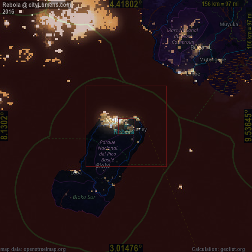
Analysis of Rebola night lights 2016
Square area 10x10 km:
 2.6%
2.6%90-99
5.19%80-89
1.95%70-79
1.73%60-69
4.76%50-59
5.19%40-49
12.55%30-39
5.41%20-29
11.47%10-19
33.98%0-9
15.15%Square area 50x50 km:
0.55%90-99
0.76%80-89
0.73%70-79
0.78%60-69
0.7%50-59
0.81%40-49
0.86%30-39
0.31%20-29
1.65%10-19
4.56%0-9
88.28%Clear (daylight) street map image can be seen on geolist.org.
Map coordinates:
4° 25' 4.9" North, 8° 7' 48.7" East
3° 43' 0" North, 8° 49' 60" East
3° 0' 53.1" North, 9° 32' 11.2" East
Some cities around Rebola sort by population:
• Malabo
7.2 km =4.5 mi,  307°
307°
• Limbe, CM
53.6 km =33.3 mi,  50°
50°
• Tiko, CM
70.7 km =43.9 mi,  55°
55°
• Mutengene, CM
67.7 km =42.1 mi, 52°
• Buea, CM
66.5 km =41.3 mi,  43°
43°
• Muyuka, CM
90.3 km =56.1 mi, 45°
• Bamusso, CM
82.9 km =51.5 mi,  5°
5°
• Luba
42.3 km =26.3 mi,  226°
226°
2306824 (p: 5,450)
Sources (retrieved 2019-11-25):
» Earth at Night: Flat Maps 2012, 2016