Market Drayton night lights from space
Night Light of Market Drayton (England) from space (United Kingdom) Src. Average luminocity for 10x10km area is 4.8624% and for 50x50km: 11.7843%.
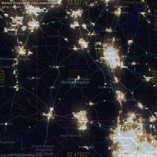
Analysis of Market Drayton night lights 2016
Square area 10x10 km:
 0.38%
0.38%90-99
0.63%80-89
0.51%70-79
0%60-69
0.25%50-59
1.77%40-49
1.01%30-39
2.4%20-29
1.14%10-19
0.51%0-9
91.41%Square area 50x50 km:
2.44%90-99
2.38%80-89
1.19%70-79
1.23%60-69
1.1%50-59
1.4%40-49
1.33%30-39
1.4%20-29
3%10-19
8.02%0-9
76.5%Clear (daylight) street map image can be seen on geolist.org.
Map coordinates:
53° 19' 38.6" North, 3° 11' 35.7" West
52° 54' 19.4" North, 2° 29' 24.4" West
52° 28' 45.2" North, 1° 47' 13.2" West
Some cities around Market Drayton sort by population:
• Newcastle under Lyme
20.2 km =12.6 mi,  58°
58°
• Crewe
21.6 km =13.4 mi,  8°
8°
• Nantwich
18.3 km =11.4 mi,  353°
353°
• Stone
22.5 km =14 mi,  89°
89°
• Newport
17.2 km =10.7 mi,  153°
153°
• Whitchurch
14.6 km =9.1 mi,  297°
297°
• Wem
16.2 km =10.1 mi,  251°
251°
• Audley
20.5 km =12.7 mi,  38°
38°
2643028 (p: 11,773)
Sources (retrieved 2019-11-25):
» Earth at Night: Flat Maps 2012, 2016