Coedpoeth night lights from space
Night Light of Coedpoeth (Wales) from space (United Kingdom) Src. Average luminocity for 10x10km area is 20.5384% and for 50x50km: 8.9992%.
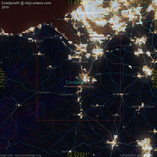
Analysis of Coedpoeth night lights 2016
Square area 10x10 km:
 2.65%
2.65%90-99
2.12%80-89
2.51%70-79
1.72%60-69
1.85%50-59
6.88%40-49
3.04%30-39
2.25%20-29
5.42%10-19
21.03%0-9
50.53%Square area 50x50 km:
1.49%90-99
1.49%80-89
0.68%70-79
0.77%60-69
1.07%50-59
1.05%40-49
1.2%30-39
1.82%20-29
3.38%10-19
7.41%0-9
79.62%Clear (daylight) street map image can be seen on geolist.org.
Map coordinates:
53° 28' 28.1" North, 3° 45' 55.7" West
53° 3' 14.1" North, 3° 3' 44.4" West
52° 37' 45.2" North, 2° 21' 33.2" West
Some cities around Coedpoeth sort by population:
• Wrexham
4.8 km =3 mi,  99°
99°
• Buckley
12.6 km =7.8 mi,  353°
353°
• Hawarden
14.8 km =9.2 mi,  9°
9°
• Rhosllanerchrugog
4.9 km =3 mi,  176°
176°
• Brymbo
1.4 km =0.9 mi, 348°
• Mold
13.6 km =8.5 mi,  337°
337°
• Broughton
13 km =8.1 mi,  20°
20°
• Gresford
7.1 km =4.4 mi,  60°
60°
2652648 (p: 5,723)
Sources (retrieved 2019-11-25):
» Earth at Night: Flat Maps 2012, 2016