Uttoxeter night lights from space
Night Light of Uttoxeter (England) from space (United Kingdom) Src. Average luminocity for 10x10km area is 10.4735% and for 50x50km: 16.4377%.
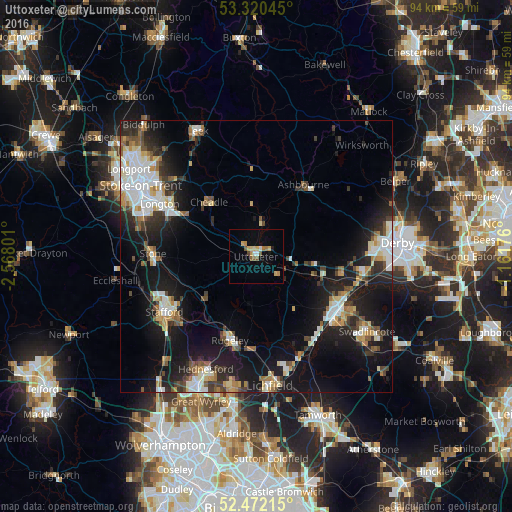
Analysis of Uttoxeter night lights 2016
Square area 10x10 km:
 0.88%
0.88%90-99
0.63%80-89
2.02%70-79
1.77%60-69
2.15%50-59
2.4%40-49
0.76%30-39
0%20-29
0.13%10-19
1.64%0-9
87.63%Square area 50x50 km:
3.05%90-99
2.85%80-89
1.63%70-79
1.59%60-69
1.72%50-59
1.99%40-49
1.88%30-39
2.19%20-29
4.51%10-19
14.2%0-9
64.39%Clear (daylight) street map image can be seen on geolist.org.
Map coordinates:
53° 19' 13.6" North, 2° 34' 4.8" West
52° 53' 54.2" North, 1° 51' 53.6" West
52° 28' 19.7" North, 1° 9' 42.3" West
Some cities around Uttoxeter sort by population:
• Burton upon Trent
18 km =11.2 mi,  124°
124°
• Stafford
19.8 km =12.3 mi,  238°
238°
• Lichfield
24.3 km =15.1 mi,  173°
173°
• Rugeley
16.2 km =10.1 mi,  197°
197°
• Stone
19.4 km =12.1 mi,  272°
272°
• Longton
20.3 km =12.6 mi,  297°
297°
• Cheadle
12.3 km =7.6 mi,  319°
319°
• Ashbourne
15.8 km =9.8 mi,  33°
33°
2635043 (p: 13,089)
Sources (retrieved 2019-11-25):
» Earth at Night: Flat Maps 2012, 2016