Syston night lights from space
Night Light of Syston (England) from space (United Kingdom) Src. Average luminocity for 10x10km area is 39.8783% and for 50x50km: 16.6224%.
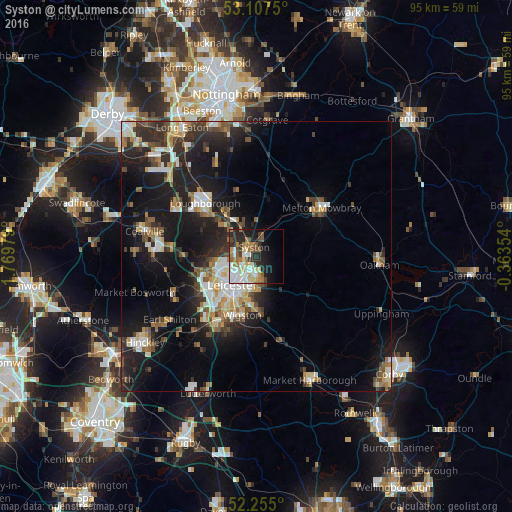
Analysis of Syston night lights 2016
Square area 10x10 km:
 6.88%
6.88%90-99
8.86%80-89
6.61%70-79
2.78%60-69
8.2%50-59
4.89%40-49
3.04%30-39
5.82%20-29
10.58%10-19
13.49%0-9
28.84%Square area 50x50 km:
2.25%90-99
2.86%80-89
1.77%70-79
1.59%60-69
2.07%50-59
2.23%40-49
2.42%30-39
2.56%20-29
5.68%10-19
13.88%0-9
62.7%Clear (daylight) street map image can be seen on geolist.org.
Map coordinates:
53° 6' 27" North, 1° 46' 11.2" West
52° 40' 60" North, 1° 4' 0" West
52° 15' 18" North, 0° 21' 48.7" West
Some cities around Syston sort by population:
• Leicester
6.6 km =4.1 mi,  221°
221°
• Oadby
8.7 km =5.4 mi,  187°
187°
• Mountsorrel
6.7 km =4.2 mi,  303°
303°
• Glenfield
9.6 km =6 mi,  244°
244°
• Sileby
6.2 km =3.9 mi,  333°
333°
• Anstey
8.3 km =5.2 mi,  262°
262°
• Barrow upon Soar
9.3 km =5.8 mi,  324°
324°
• Quorndon
9.9 km =6.2 mi,  313°
313°
2636341 (p: 11,508)
Sources (retrieved 2019-11-25):
» Earth at Night: Flat Maps 2012, 2016