Mountsorrel night lights from space
Night Light of Mountsorrel (England) from space (United Kingdom) Src. Average luminocity for 10x10km area is 35.9811% and for 50x50km: 21.3607%.
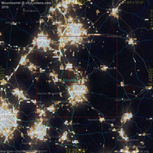
Analysis of Mountsorrel night lights 2016
Square area 10x10 km:
 2.15%
2.15%90-99
3.28%80-89
3.54%70-79
2.27%60-69
11.24%50-59
4.67%40-49
5.81%30-39
10.1%20-29
22.1%10-19
29.67%0-9
5.18%Square area 50x50 km:
3.84%90-99
4.26%80-89
2.21%70-79
1.98%60-69
2.42%50-59
2.43%40-49
2.83%30-39
2.99%20-29
6.94%10-19
15.06%0-9
55.03%Clear (daylight) street map image can be seen on geolist.org.
Map coordinates:
53° 8' 25.9" North, 1° 51' 11.3" West
52° 43' 0" North, 1° 9' 0" West
52° 17' 19.2" North, 0° 26' 48.8" West
Some cities around Mountsorrel sort by population:
• Leicester
8.8 km =5.5 mi,  171°
171°
• Loughborough
6.5 km =4 mi,  328°
328°
• Syston
6.7 km =4.2 mi,  123°
123°
• Glenfield
8.4 km =5.2 mi,  201°
201°
• Sileby
3.4 km =2.1 mi,  57°
57°
• Anstey
5.4 km =3.4 mi,  208°
208°
• Barrow upon Soar
3.9 km =2.4 mi,  3°
3°
• Quorndon
3.5 km =2.2 mi, 333°
2642096 (p: 17,297)
Sources (retrieved 2019-11-25):
» Earth at Night: Flat Maps 2012, 2016