Anstey night lights from space
Night Light of Anstey (England) from space (United Kingdom) Src. Average luminocity for 10x10km area is 48.5833% and for 50x50km: 19.4695%.
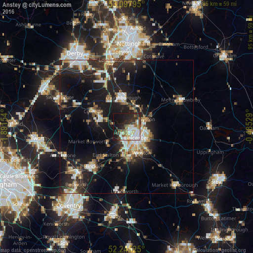
Analysis of Anstey night lights 2016
Square area 10x10 km:
 12.04%
90-99
11.51%80-89
4.37%70-79
3.57%60-69
4.89%50-59
5.95%40-49
5.42%30-39
8.73%20-29
14.29%10-19
23.28%0-9
5.95%Square area 50x50 km:
2.69%90-99
3.43%80-89
2.05%70-79
1.73%60-69
2.36%50-59
2.47%40-49
2.66%30-39
3.18%20-29
7.09%10-19
16.67%0-9
55.68%Clear (daylight) street map image can be seen on geolist.org.
Map coordinates:
53° 5' 52.6" North, 1° 53' 29.5" West
52° 40' 25.2" North, 1° 11' 18.3" West
52° 14' 42.9" North, 0° 29' 7" West
Some cities around Anstey sort by population:
• Leicester
5.5 km =3.4 mi,  135°
135°
• Mountsorrel
5.4 km =3.4 mi,  28°
28°
• Syston
8.3 km =5.2 mi,  82°
82°
• Glenfield
3 km =1.9 mi,  188°
188°
• Kirby Muxloe
5.5 km =3.4 mi,  208°
208°
• Sileby
8.5 km =5.3 mi,  39°
39°
• Barrow upon Soar
9.1 km =5.7 mi,  18°
18°
• Quorndon
8 km =5 mi,  7°
7°
2657268 (p: 6,528)
Sources (retrieved 2019-11-25):
» Earth at Night: Flat Maps 2012, 2016