Southwater night lights from space
Night Light of Southwater (England) from space (United Kingdom) Src. Average luminocity for 10x10km area is 8.0267% and for 50x50km: 11.4047%.
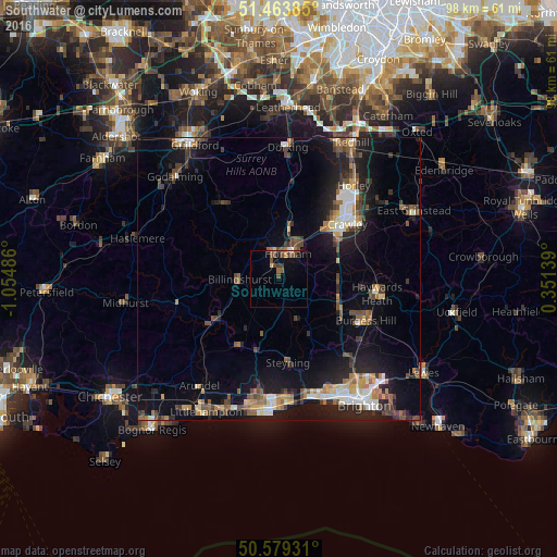
Analysis of Southwater night lights 2016
Square area 10x10 km:
 0.4%
0.4%90-99
0.13%80-89
0.8%70-79
0.53%60-69
1.47%50-59
3.48%40-49
2.94%30-39
0.94%20-29
0%10-19
2.01%0-9
87.3%Square area 50x50 km:
1.17%90-99
1.65%80-89
0.96%70-79
1.29%60-69
1.52%50-59
1.69%40-49
2.29%30-39
1.77%20-29
2.97%10-19
9.44%0-9
75.25%Clear (daylight) street map image can be seen on geolist.org.
Map coordinates:
51° 27' 49.9" North, 1° 3' 17.5" West
51° 1' 25.3" North, 0° 21' 6.2" West
50° 34' 45.5" North, 0° 21' 5" East
Some cities around Southwater sort by population:
• Crawley
15.4 km =9.6 mi,  49°
49°
• Horsham
4.7 km =2.9 mi,  21°
21°
• Broadfield
13 km =8.1 mi, 51°
• Steyning
15.2 km =9.4 mi,  173°
173°
• Bewbush
12.6 km =7.8 mi, 45°
• Storrington
13.8 km =8.6 mi,  211°
211°
• Billingshurst
7.1 km =4.4 mi,  269°
269°
• Gossops Green
13.5 km =8.4 mi,  44°
44°
2637298 (p: 8,692)
Sources (retrieved 2019-11-25):
» Earth at Night: Flat Maps 2012, 2016