Shelley night lights from space
Night Light of Shelley (England) from space (United Kingdom) Src. Average luminocity for 10x10km area is 18.6679% and for 50x50km: 38.7922%.
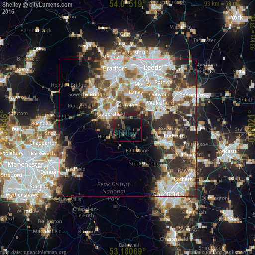
Analysis of Shelley night lights 2016
Square area 10x10 km:
 0.88%
0.88%90-99
1.01%80-89
0.38%70-79
0.51%60-69
2.9%50-59
3.54%40-49
5.05%30-39
5.93%20-29
11.74%10-19
23.86%0-9
44.19%Square area 50x50 km:
9.98%90-99
8.94%80-89
3.58%70-79
4.12%60-69
4.51%50-59
4.89%40-49
4.98%30-39
6.95%20-29
9.11%10-19
7.35%0-9
35.59%Clear (daylight) street map image can be seen on geolist.org.
Map coordinates:
54° 0' 54.7" North, 2° 23' 11.3" West
53° 36' 0" North, 1° 40' 60" West
53° 10' 50.5" North, 0° 58' 48.8" West
Some cities around Shelley sort by population:
• Huddersfield
8.6 km =5.3 mi,  309°
309°
• Mirfield
8.2 km =5.1 mi,  353°
353°
• Darton
10.4 km =6.5 mi,  97°
97°
• Penistone
9 km =5.6 mi,  157°
157°
• Horbury
10.5 km =6.5 mi,  50°
50°
• Meltham Mills
10.4 km =6.5 mi,  266°
266°
• Clayton West
4.8 km =3 mi, 96°
• Shepley
2.9 km =1.8 mi,  229°
229°
2638065 (p: 5,359)
Sources (retrieved 2019-11-25):
» Earth at Night: Flat Maps 2012, 2016