Selkirk night lights from space
Night Light of Selkirk (Scotland) from space (United Kingdom) Src. Average luminocity for 10x10km area is 2.2419% and for 50x50km: 0.6581%.
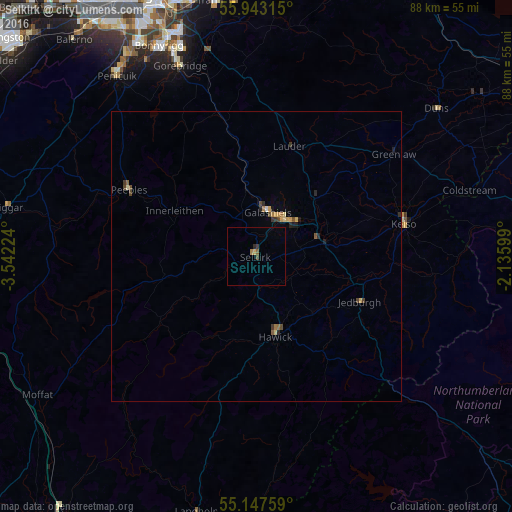
Analysis of Selkirk night lights 2016
Square area 10x10 km:
 0%
0%90-99
0%80-89
0.5%70-79
0%60-69
0.5%50-59
0.5%40-49
0.5%30-39
0.5%20-29
0.5%10-19
0%0-9
96.99%Square area 50x50 km:
0.01%90-99
0.02%80-89
0.14%70-79
0.1%60-69
0.12%50-59
0.09%40-49
0.19%30-39
0.14%20-29
0.14%10-19
0.12%0-9
98.93%Clear (daylight) street map image can be seen on geolist.org.
Map coordinates:
55° 56' 35.3" North, 3° 32' 32.1" West
55° 32' 50.6" North, 2° 50' 20.8" West
55° 8' 51.3" North, 2° 8' 9.6" West
Some cities around Selkirk sort by population:
• Bonnyrigg
39.9 km =24.8 mi,  335°
335°
• Penicuik
39.8 km =24.7 mi,  322°
322°
• Hawick
14.2 km =8.8 mi,  166°
166°
• Mayfield
38.2 km =23.7 mi, 340°
• Galashiels
7.7 km =4.8 mi,  15°
15°
• Peebles
24.9 km =15.5 mi,  297°
297°
• Gorebridge
35.6 km =22.1 mi, 338°
• Kelso
26.1 km =16.2 mi,  77°
77°
2638229 (p: 5,730)
Sources (retrieved 2019-11-25):
» Earth at Night: Flat Maps 2012, 2016