Bonnyrigg night lights from space
Night Light of Bonnyrigg (Scotland) from space (United Kingdom) Src. Average luminocity for 10x10km area is 50.797% and for 50x50km: 13.4409%.
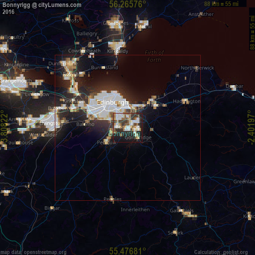
Analysis of Bonnyrigg night lights 2016
Square area 10x10 km:
 10.28%
90-99
12.41%80-89
4.51%70-79
5.01%60-69
5.51%50-59
8.15%40-49
4.76%30-39
12.28%20-29
14.66%10-19
21.3%0-9
1.13%Square area 50x50 km:
2.91%90-99
3.13%80-89
1.23%70-79
1.11%60-69
1.26%50-59
1.24%40-49
1.14%30-39
1.82%20-29
5.27%10-19
7.78%0-9
73.11%Clear (daylight) street map image can be seen on geolist.org.
Map coordinates:
56° 15' 56.7" North, 3° 48' 29.6" West
55° 52' 23.8" North, 3° 6' 18.4" West
55° 28' 36.5" North, 2° 24' 7.1" West
Some cities around Bonnyrigg sort by population:
• Edinburgh
10.4 km =6.5 mi,  326°
326°
• Musselburgh
8.3 km =5.2 mi,  24°
24°
• Penicuik
8.9 km =5.5 mi,  238°
238°
• Mayfield
4.1 km =2.5 mi,  92°
92°
• Dalkeith
3.2 km =2 mi,  46°
46°
• Colinton
10.1 km =6.3 mi,  291°
291°
• Loanhead
3.4 km =2.1 mi,  281°
281°
• Gorebridge
4.8 km =3 mi,  129°
129°
2655210 (p: 16,360)
Sources (retrieved 2019-11-25):
» Earth at Night: Flat Maps 2012, 2016