Peebles night lights from space
Night Light of Peebles (Scotland) from space (United Kingdom) Src. Average luminocity for 10x10km area is 1.6411% and for 50x50km: 2.2007%.
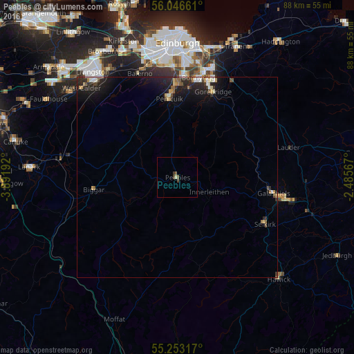
Analysis of Peebles night lights 2016
Square area 10x10 km:
 0%
0%90-99
0.24%80-89
0.24%70-79
0%60-69
0.12%50-59
0.72%40-49
0.96%30-39
0.6%20-29
0%10-19
0%0-9
97.13%Square area 50x50 km:
0.19%90-99
0.31%80-89
0.24%70-79
0.19%60-69
0.2%50-59
0.27%40-49
0.25%30-39
0.28%20-29
1.18%10-19
2.42%0-9
94.47%Clear (daylight) street map image can be seen on geolist.org.
Map coordinates:
56° 2' 47.8" North, 3° 53' 30.9" West
55° 39' 6.8" North, 3° 11' 19.7" West
55° 15' 11.4" North, 2° 29' 8.4" West
Some cities around Peebles sort by population:
• Bonnyrigg
25.2 km =15.7 mi,  12°
12°
• Penicuik
20.1 km =12.5 mi,  353°
353°
• Mayfield
26.2 km =16.3 mi,  21°
21°
• Galashiels
24.3 km =15.1 mi,  99°
99°
• Loanhead
25.4 km =15.8 mi,  4°
4°
• Gorebridge
23.4 km =14.5 mi, 22°
• Balerno
27.5 km =17.1 mi,  339°
339°
• Selkirk
24.9 km =15.5 mi,  117°
117°
2640526 (p: 8,380)
Sources (retrieved 2019-11-25):
» Earth at Night: Flat Maps 2012, 2016