Sandy night lights from space
Night Light of Sandy (England) from space (United Kingdom) Src. Average luminocity for 10x10km area is 13.9246% and for 50x50km: 10.0997%.
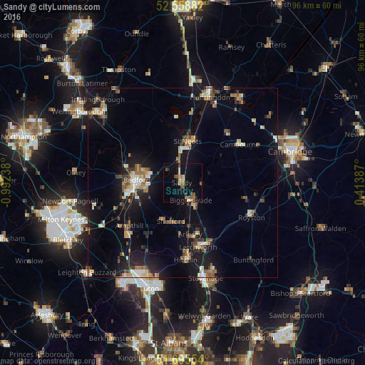
Analysis of Sandy night lights 2016
Square area 10x10 km:
 0.13%
0.13%90-99
0.13%80-89
2.91%70-79
0.79%60-69
2.78%50-59
4.1%40-49
2.91%30-39
1.06%20-29
1.85%10-19
8.86%0-9
74.47%Square area 50x50 km:
0.8%90-99
1.16%80-89
1.12%70-79
1.13%60-69
1.44%50-59
1.4%40-49
1.5%30-39
1.42%20-29
2.37%10-19
9.91%0-9
77.75%Clear (daylight) street map image can be seen on geolist.org.
Map coordinates:
52° 33' 31.8" North, 0° 59' 32.6" West
52° 7' 45.4" North, 0° 17' 21.3" West
51° 41' 43.9" North, 0° 24' 49.9" East
Some cities around Sandy sort by population:
• Bedford
12.1 km =7.5 mi,  272°
272°
• Saint Neots
9.8 km =6.1 mi,  9°
9°
• Biggleswade
5 km =3.1 mi,  160°
160°
• Eaton Socon
9.8 km =6.1 mi,  0°
0°
• Henlow
11 km =6.8 mi,  178°
178°
• Shefford
10.5 km =6.5 mi,  196°
196°
• Stotfold
13.2 km =8.2 mi, 162°
• Arlesey
13.7 km =8.5 mi,  173°
173°
2638530 (p: 11,657)
Sources (retrieved 2019-11-25):
» Earth at Night: Flat Maps 2012, 2016