Arlesey night lights from space
Night Light of Arlesey (England) from space (United Kingdom) Src. Average luminocity for 10x10km area is 18.7677% and for 50x50km: 12.8303%.
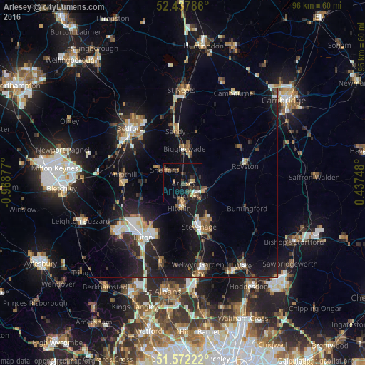
Analysis of Arlesey night lights 2016
Square area 10x10 km:
 1.14%
1.14%90-99
0.88%80-89
2.4%70-79
1.26%60-69
2.78%50-59
2.4%40-49
5.56%30-39
6.82%20-29
4.55%10-19
17.05%0-9
55.18%Square area 50x50 km:
1.52%90-99
1.81%80-89
1.32%70-79
1.17%60-69
1.44%50-59
1.63%40-49
1.63%30-39
2.01%20-29
4.1%10-19
13.51%0-9
69.86%Clear (daylight) street map image can be seen on geolist.org.
Map coordinates:
52° 26' 16.3" North, 0° 58' 7.6" West
52° 0' 25.7" North, 0° 15' 56.3" West
51° 34' 20" North, 0° 26' 14.9" East
Some cities around Arlesey sort by population:
• Letchworth Garden City
4.1 km =2.5 mi,  139°
139°
• Hitchin
6.6 km =4.1 mi,  191°
191°
• Letchworth
4 km =2.5 mi, 140°
• Biggleswade
8.8 km =5.5 mi,  0°
0°
• Henlow
2.9 km =1.8 mi,  331°
331°
• Shefford
5.8 km =3.6 mi,  306°
306°
• Baldock
5.7 km =3.5 mi,  112°
112°
• Stotfold
2.5 km =1.6 mi,  66°
66°
2657073 (p: 5,584)
Sources (retrieved 2019-11-25):
» Earth at Night: Flat Maps 2012, 2016