Prudhoe night lights from space
Night Light of Prudhoe (England) from space (United Kingdom) Src. Average luminocity for 10x10km area is 6.6722% and for 50x50km: 18.1346%.
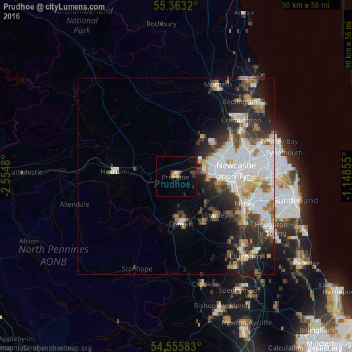
Analysis of Prudhoe night lights 2016
Square area 10x10 km:
 0.12%
0.12%90-99
0.36%80-89
0.12%70-79
2.03%60-69
0.72%50-59
0.48%40-49
1.67%30-39
0.72%20-29
2.39%10-19
2.99%0-9
88.4%Square area 50x50 km:
5.16%90-99
4.05%80-89
1.64%70-79
1.55%60-69
1.84%50-59
1.81%40-49
1.72%30-39
3%20-29
4.4%10-19
5.77%0-9
69.05%Clear (daylight) street map image can be seen on geolist.org.
Map coordinates:
55° 21' 47.5" North, 2° 33' 17.3" West
54° 57' 41.5" North, 1° 51' 6" West
54° 33' 21" North, 1° 8' 54.8" West
Some cities around Prudhoe sort by population:
• Newburn
7.4 km =4.6 mi,  67°
67°
• Consett
12 km =7.5 mi,  173°
173°
• Whickham
11.3 km =7 mi,  98°
98°
• Darras Hall
9.9 km =6.2 mi,  34°
34°
• Blaydon-on-Tyne
8.8 km =5.5 mi,  87°
87°
• Ponteland
12 km =7.5 mi, 34°
• Benwell
11.7 km =7.3 mi,  83°
83°
• Rowlands Gill
8.3 km =5.2 mi,  124°
124°
2639874 (p: 12,075)
Sources (retrieved 2019-11-25):
» Earth at Night: Flat Maps 2012, 2016