Whickham night lights from space
Night Light of Whickham (England) from space (United Kingdom) Src. Average luminocity for 10x10km area is 60.4785% and for 50x50km: 24.3033%.
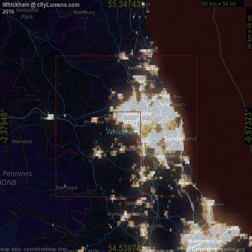
Analysis of Whickham night lights 2016
Square area 10x10 km:
 23.8%
23.8%90-99
15.43%80-89
3.95%70-79
3.47%60-69
4.07%50-59
3.35%40-49
3.95%30-39
11.36%20-29
13.04%10-19
15.07%0-9
2.51%Square area 50x50 km:
7.36%90-99
5.26%80-89
2%70-79
2%60-69
2.25%50-59
2.24%40-49
2.19%30-39
3.9%20-29
6.46%10-19
9.21%0-9
57.13%Clear (daylight) street map image can be seen on geolist.org.
Map coordinates:
55° 20' 50.7" North, 2° 22' 46.1" West
54° 56' 44.2" North, 1° 40' 34.9" West
54° 32' 23.1" North, 0° 58' 23.6" West
Some cities around Whickham sort by population:
• Newcastle upon Tyne
5 km =3.1 mi,  52°
52°
• Gateshead
5.1 km =3.2 mi,  68°
68°
• Newburn
6.4 km =4 mi,  317°
317°
• Felling
6.7 km =4.2 mi,  83°
83°
• Gosforth
7.1 km =4.4 mi,  32°
32°
• Blaydon-on-Tyne
3.2 km =2 mi,  311°
311°
• Benwell
3.1 km =1.9 mi,  8°
8°
• Rowlands Gill
5.3 km =3.3 mi,  236°
236°
2634155 (p: 16,625)
Sources (retrieved 2019-11-25):
» Earth at Night: Flat Maps 2012, 2016