Porthcawl night lights from space
Night Light of Porthcawl (Wales) from space (United Kingdom) Src. Average luminocity for 10x10km area is 11.1029% and for 50x50km: 9.5707%.
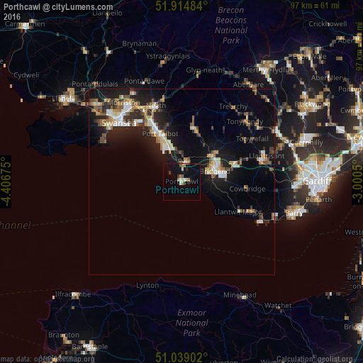
Analysis of Porthcawl night lights 2016
Square area 10x10 km:
 0.53%
0.53%90-99
1.6%80-89
1.6%70-79
0%60-69
2.81%50-59
1.6%40-49
0.4%30-39
1.6%20-29
0.8%10-19
8.56%0-9
80.48%Square area 50x50 km:
1.1%90-99
1.46%80-89
0.81%70-79
1.09%60-69
1.44%50-59
1.23%40-49
1.23%30-39
1.35%20-29
2.99%10-19
8.46%0-9
78.86%Clear (daylight) street map image can be seen on geolist.org.
Map coordinates:
51° 54' 53.4" North, 4° 24' 24.3" West
51° 28' 44.5" North, 3° 42' 13" West
51° 2' 20.5" North, 3° 0' 1.8" West
Some cities around Porthcawl sort by population:
• Bridgend
9.2 km =5.7 mi,  71°
71°
• Coity
11.3 km =7 mi, 65°
• Maesteg
14.8 km =9.2 mi,  12°
12°
• Llantwit Major
16.9 km =10.5 mi,  116°
116°
• Pyle
4.2 km =2.6 mi,  3°
3°
• Aberkenfig
10.1 km =6.3 mi,  47°
47°
• Pencoed
14.9 km =9.3 mi, 70°
• Cwmafan
15.8 km =9.8 mi,  345°
345°
2640054 (p: 15,672)
Sources (retrieved 2019-11-25):
» Earth at Night: Flat Maps 2012, 2016