Hartshill night lights from space
Night Light of Hartshill (England) from space (United Kingdom) Src. Average luminocity for 10x10km area is 29.078% and for 50x50km: 32.0688%.
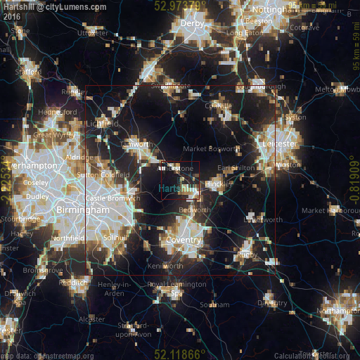
Analysis of Hartshill night lights 2016
Square area 10x10 km:
 4.23%
4.23%90-99
5.42%80-89
3.84%70-79
2.78%60-69
4.37%50-59
1.46%40-49
4.63%30-39
2.78%20-29
7.54%10-19
32.28%0-9
30.69%Square area 50x50 km:
7.37%90-99
7.08%80-89
2.73%70-79
2.81%60-69
3.37%50-59
3.19%40-49
3.18%30-39
3.52%20-29
9.14%10-19
24.06%0-9
33.56%Clear (daylight) street map image can be seen on geolist.org.
Map coordinates:
52° 58' 25.6" North, 2° 13' 31.2" West
52° 32' 53.9" North, 1° 31' 20" West
52° 7' 7.2" North, 0° 49' 8.7" West
Some cities around Hartshill sort by population:
• Nuneaton
4.8 km =3 mi,  125°
125°
• Hinckley
9.9 km =6.2 mi,  96°
96°
• Bedworth
8.5 km =5.3 mi,  154°
154°
• Earl Shilton
14.3 km =8.9 mi,  77°
77°
• Atherstone
3.4 km =2.1 mi,  330°
330°
• Attleborough
6 km =3.7 mi, 130°
• Polesworth
9.9 km =6.2 mi,  323°
323°
• Fazeley
14 km =8.7 mi,  301°
301°
2647391 (p: 12,479)
Sources (retrieved 2019-11-25):
» Earth at Night: Flat Maps 2012, 2016