Brierfield night lights from space
Night Light of Brierfield (England) from space (United Kingdom) Src. Average luminocity for 10x10km area is 35.0886% and for 50x50km: 13.7604%.
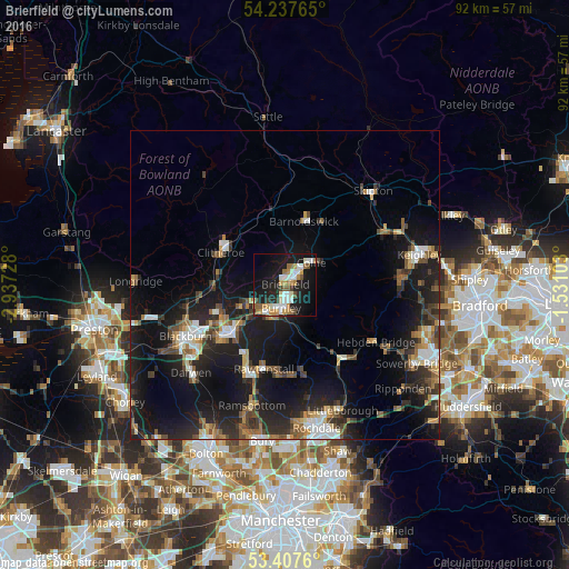
Analysis of Brierfield night lights 2016
Square area 10x10 km:
 5.56%
5.56%90-99
8.73%80-89
1.59%70-79
6.35%60-69
6.22%50-59
2.78%40-49
2.51%30-39
2.25%20-29
6.88%10-19
35.19%0-9
21.96%Square area 50x50 km:
1.59%90-99
1.86%80-89
0.87%70-79
1.46%60-69
1.91%50-59
2.01%40-49
2.04%30-39
2.39%20-29
5.26%10-19
15.41%0-9
65.2%Clear (daylight) street map image can be seen on geolist.org.
Map coordinates:
54° 14' 15.5" North, 2° 56' 14.2" West
53° 49' 28.8" North, 2° 14' 2.9" West
53° 24' 27.4" North, 1° 31' 51.7" West
Some cities around Brierfield sort by population:
• Burnley
2.7 km =1.7 mi,  178°
178°
• Accrington
11.4 km =7.1 mi,  226°
226°
• Nelson
2.4 km =1.5 mi,  66°
66°
• Colne
5.6 km =3.5 mi,  50°
50°
• Padiham
5.9 km =3.7 mi,  244°
244°
• Barnoldswick
10.7 km =6.6 mi,  16°
16°
• Clayton le Moors
11.7 km =7.3 mi, 236°
• Barrowford
2.6 km =1.6 mi, 23°
2654725 (p: 10,271)
Sources (retrieved 2019-11-25):
» Earth at Night: Flat Maps 2012, 2016