Oswestry night lights from space
Night Light of Oswestry (England) from space (United Kingdom) Src. Average luminocity for 10x10km area is 6.0404% and for 50x50km: 3.1087%.
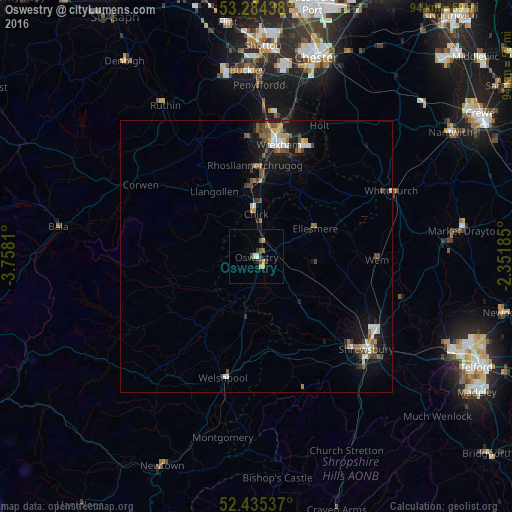
Analysis of Oswestry night lights 2016
Square area 10x10 km:
 0.25%
0.25%90-99
0.63%80-89
1.14%70-79
1.01%60-69
0.38%50-59
1.64%40-49
0.13%30-39
1.89%20-29
0.51%10-19
0.63%0-9
91.79%Square area 50x50 km:
0.35%90-99
0.4%80-89
0.26%70-79
0.36%60-69
0.37%50-59
0.6%40-49
0.55%30-39
0.48%20-29
0.52%10-19
2.59%0-9
93.53%Clear (daylight) street map image can be seen on geolist.org.
Map coordinates:
53° 17' 3.8" North, 3° 45' 29.2" West
52° 51' 43" North, 3° 3' 17.9" West
52° 26' 7.3" North, 2° 21' 6.7" West
Some cities around Oswestry sort by population:
• Shrewsbury
26.5 km =16.5 mi,  129°
129°
• Wrexham
21 km =13 mi,  11°
11°
• Rhosllanerchrugog
16.4 km =10.2 mi,  359°
359°
• Brymbo
22.8 km =14.2 mi, 358°
• Welshpool
23.3 km =14.5 mi,  195°
195°
• Wem
22.6 km =14 mi,  91°
91°
• Coedpoeth
21.3 km =13.2 mi, 358°
• Gresford
25.5 km =15.8 mi, 12°
2640861 (p: 18,743)
Sources (retrieved 2019-11-25):
» Earth at Night: Flat Maps 2012, 2016