Kirby Muxloe night lights from space
Night Light of Kirby Muxloe (England) from space (United Kingdom) Src. Average luminocity for 10x10km area is 48.918% and for 50x50km: 19.6737%.
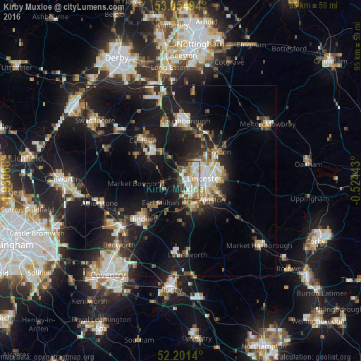
Analysis of Kirby Muxloe night lights 2016
Square area 10x10 km:
 11.11%
90-99
12.7%80-89
5.95%70-79
5.82%60-69
5.42%50-59
5.56%40-49
5.03%30-39
5.42%20-29
7.01%10-19
17.99%0-9
17.99%Square area 50x50 km:
2.98%90-99
3.59%80-89
2.07%70-79
1.82%60-69
2.31%50-59
2.57%40-49
2.37%30-39
2.42%20-29
5.86%10-19
18.4%0-9
55.62%Clear (daylight) street map image can be seen on geolist.org.
Map coordinates:
53° 3' 17.8" North, 1° 55' 50.4" West
52° 37' 48.9" North, 1° 13' 39.2" West
52° 12' 5" North, 0° 31' 27.9" West
Some cities around Kirby Muxloe sort by population:
• Leicester
6.5 km =4 mi,  81°
81°
• Oadby
10.1 km =6.3 mi,  105°
105°
• Earl Shilton
8.4 km =5.2 mi,  224°
224°
• Glenfield
2.9 km =1.8 mi,  50°
50°
• Enderby
4.9 km =3 mi,  163°
163°
• Anstey
5.5 km =3.4 mi,  28°
28°
• Narborough
7.3 km =4.5 mi,  165°
165°
• Blaby
7.4 km =4.6 mi,  144°
144°
2645335 (p: 9,712)
Sources (retrieved 2019-11-25):
» Earth at Night: Flat Maps 2012, 2016