Milnrow night lights from space
Night Light of Milnrow (England) from space (United Kingdom) Src. Average luminocity for 10x10km area is 54.4634% and for 50x50km: 40.1276%.
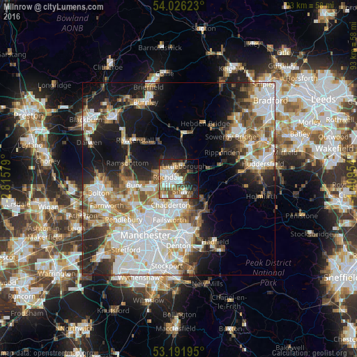
Analysis of Milnrow night lights 2016
Square area 10x10 km:
 12.75%
90-99
12.88%80-89
4.17%70-79
6.69%60-69
8.59%50-59
7.83%40-49
7.2%30-39
6.44%20-29
14.52%10-19
11.87%0-9
7.07%Square area 50x50 km:
11.68%90-99
9.15%80-89
3.72%70-79
3.99%60-69
5.23%50-59
4.81%40-49
3.94%30-39
3.96%20-29
7.34%10-19
13.06%0-9
33.11%Clear (daylight) street map image can be seen on geolist.org.
Map coordinates:
54° 1' 34.4" North, 2° 48' 56.8" West
53° 36' 40.1" North, 2° 6' 45.6" West
53° 11' 31" North, 1° 24' 34.3" West
Some cities around Milnrow sort by population:
• Oldham
7.9 km =4.9 mi,  182°
182°
• Rochdale
2.9 km =1.8 mi,  284°
284°
• Middleton
8.9 km =5.5 mi,  220°
220°
• Heywood
7.3 km =4.5 mi,  253°
253°
• Royton
5.2 km =3.2 mi,  187°
187°
• Littleborough
3.8 km =2.4 mi,  16°
16°
• Wardle
4.5 km =2.8 mi,  342°
342°
• Whitworth
6.6 km =4.1 mi,  319°
319°
2642483 (p: 13,061)
Sources (retrieved 2019-11-25):
» Earth at Night: Flat Maps 2012, 2016