Marske-by-the-Sea night lights from space
Night Light of Marske-by-the-Sea (England) from space (United Kingdom) Src. Average luminocity for 10x10km area is 32.6328% and for 50x50km: 13.3667%.
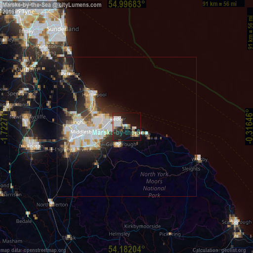
Analysis of Marske-by-the-Sea night lights 2016
Square area 10x10 km:
 6.1%
6.1%90-99
8.01%80-89
2.27%70-79
2.39%60-69
2.99%50-59
3.71%40-49
2.75%30-39
3.11%20-29
13.88%10-19
30.86%0-9
23.92%Square area 50x50 km:
3.04%90-99
3.31%80-89
1.18%70-79
1.19%60-69
1.32%50-59
1.34%40-49
1.22%30-39
1.94%20-29
3.7%10-19
6.95%0-9
74.82%Clear (daylight) street map image can be seen on geolist.org.
Map coordinates:
54° 59' 48.6" North, 1° 43' 21.8" West
54° 35' 29.3" North, 1° 1' 10.5" West
54° 10' 55.3" North, 0° 18' 59.3" West
Some cities around Marske-by-the-Sea sort by population:
• Middlesbrough
14 km =8.7 mi,  263°
263°
• Hartlepool
16.1 km =10 mi,  310°
310°
• Redcar
3.8 km =2.4 mi,  317°
317°
• Guisborough
6.7 km =4.2 mi,  200°
200°
• Ingleby Greenhow
16.7 km =10.4 mi, 199°
• Skelton
4 km =2.5 mi,  149°
149°
• Saltburn-by-the-Sea
3.1 km =1.9 mi,  108°
108°
• Brotton
5.9 km =3.7 mi,  118°
118°
2642974 (p: 8,282)
Sources (retrieved 2019-11-25):
» Earth at Night: Flat Maps 2012, 2016