Longfield night lights from space
Night Light of Longfield (England) from space (United Kingdom) Src. Average luminocity for 10x10km area is 32.9552% and for 50x50km: 42.0776%.
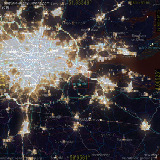
Analysis of Longfield night lights 2016
Square area 10x10 km:
 3.5%
3.5%90-99
5.46%80-89
3.5%70-79
4.2%60-69
5.18%50-59
1.26%40-49
5.32%30-39
9.24%20-29
17.37%10-19
22.27%0-9
22.69%Square area 50x50 km:
12.44%90-99
9.22%80-89
4.75%70-79
4.23%60-69
4.37%50-59
4.09%40-49
4.07%30-39
5.45%20-29
8.52%10-19
13.12%0-9
29.73%Clear (daylight) street map image can be seen on geolist.org.
Map coordinates:
51° 50' 0.6" North, 0° 24' 3.6" West
51° 23' 48.8" North, 0° 18' 7.6" East
50° 57' 22" North, 1° 0' 18.9" East
Some cities around Longfield sort by population:
• Grays
8.9 km =5.5 mi,  10°
10°
• Dartford
8.2 km =5.1 mi,  312°
312°
• Gravesend
6.9 km =4.3 mi,  43°
43°
• Hartley
1.1 km =0.7 mi,  174°
174°
• Swanscombe
5.6 km =3.5 mi, 5°
• Tilbury
8.3 km =5.2 mi,  28°
28°
• Stone
6.5 km =4 mi,  336°
336°
• West Kingsdown
6.6 km =4.1 mi,  205°
205°
2643696 (p: 16,808)
Sources (retrieved 2019-11-25):
» Earth at Night: Flat Maps 2012, 2016