Flitwick night lights from space
Night Light of Flitwick (England) from space (United Kingdom) Src. Average luminocity for 10x10km area is 13.1098% and for 50x50km: 18.4837%.
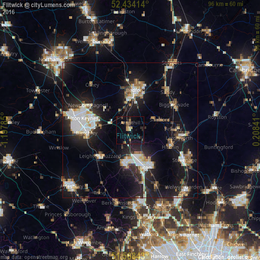
Analysis of Flitwick night lights 2016
Square area 10x10 km:
 0%
0%90-99
0%80-89
1.52%70-79
3.03%60-69
1.52%50-59
2.02%40-49
2.53%30-39
1.14%20-29
3.79%10-19
14.65%0-9
69.82%Square area 50x50 km:
3.42%90-99
3.42%80-89
1.83%70-79
1.48%60-69
1.68%50-59
1.71%40-49
1.81%30-39
2.48%20-29
6.02%10-19
16.87%0-9
59.29%Clear (daylight) street map image can be seen on geolist.org.
Map coordinates:
52° 26' 2.9" North, 1° 11' 52.3" West
52° 0' 12.2" North, 0° 29' 41" West
51° 34' 6.3" North, 0° 12' 30.3" East
Some cities around Flitwick sort by population:
• Dunstable
13.2 km =8.2 mi,  188°
188°
• Ampthill
2.6 km =1.6 mi,  358°
358°
• Kempston Hardwick
9.6 km =6 mi, 358°
• Kempston
12.5 km =7.8 mi, 358°
• Henlow
14.6 km =9.1 mi,  78°
78°
• Shefford
11.7 km =7.3 mi,  70°
70°
• Cranfield
10.7 km =6.6 mi,  312°
312°
• Woburn Sands
10.7 km =6.6 mi,  277°
277°
2649295 (p: 12,983)
Sources (retrieved 2019-11-25):
» Earth at Night: Flat Maps 2012, 2016