Barton upon Humber night lights from space
Night Light of Barton upon Humber (England) from space (United Kingdom) Src. Average luminocity for 10x10km area is 24.5871% and for 50x50km: 12.896%.
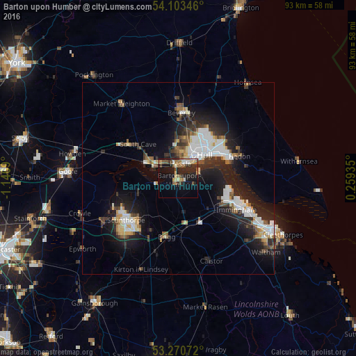
Analysis of Barton upon Humber night lights 2016
Square area 10x10 km:
 2.15%
2.15%90-99
2.4%80-89
3.91%70-79
2.02%60-69
4.42%50-59
4.29%40-49
3.16%30-39
3.41%20-29
12.12%10-19
21.09%0-9
41.04%Square area 50x50 km:
2.48%90-99
2.7%80-89
1.06%70-79
1.03%60-69
0.99%50-59
1.48%40-49
1.37%30-39
1.95%20-29
4.82%10-19
9.47%0-9
72.64%Clear (daylight) street map image can be seen on geolist.org.
Map coordinates:
54° 6' 12.5" North, 1° 8' 48.8" West
53° 41' 20.9" North, 0° 26' 37.6" West
53° 16' 14.6" North, 0° 15' 33.7" East
Some cities around Barton upon Humber sort by population:
• Kingston upon Hull
9.4 km =5.8 mi,  49°
49°
• Scunthorpe
18.5 km =11.5 mi,  228°
228°
• Beverley
17.5 km =10.9 mi,  4°
4°
• Brough
9.5 km =5.9 mi,  297°
297°
• Immingham
17.2 km =10.7 mi,  119°
119°
• Hedon
17.2 km =10.7 mi,  70°
70°
• North Ferriby
5.4 km =3.4 mi,  311°
311°
• Brigg
15.6 km =9.7 mi,  191°
191°
2656206 (p: 11,066)
Sources (retrieved 2019-11-25):
» Earth at Night: Flat Maps 2012, 2016