Hexham night lights from space
Night Light of Hexham (England) from space (United Kingdom) Src. Average luminocity for 10x10km area is 5.1184% and for 50x50km: 2.1183%.
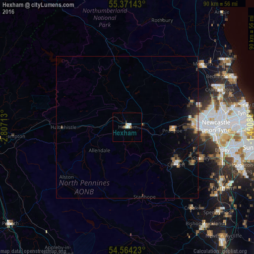
Analysis of Hexham night lights 2016
Square area 10x10 km:
 1.32%
1.32%90-99
1.2%80-89
0.84%70-79
0%60-69
0.48%50-59
0.48%40-49
0%30-39
0.6%20-29
0.36%10-19
0%0-9
94.74%Square area 50x50 km:
0.18%90-99
0.24%80-89
0.18%70-79
0.28%60-69
0.33%50-59
0.17%40-49
0.33%30-39
0.6%20-29
0.64%10-19
1.16%0-9
95.9%Clear (daylight) street map image can be seen on geolist.org.
Map coordinates:
55° 22' 17.1" North, 2° 48' 25.7" West
54° 58' 11.5" North, 2° 6' 14.4" West
54° 33' 51.2" North, 1° 24' 3.2" West
Some cities around Hexham sort by population:
• Newburn
23 km =14.3 mi,  85°
85°
• Consett
21.7 km =13.5 mi,  126°
126°
• Darras Hall
22.9 km =14.2 mi,  71°
71°
• Blaydon-on-Tyne
24.9 km =15.5 mi, 91°
• Prudhoe
16.1 km =10 mi, 93°
• Annfield Plain
26.5 km =16.5 mi,  118°
118°
• Ponteland
24.6 km =15.3 mi, 68°
• Rowlands Gill
23.6 km =14.7 mi,  103°
103°
2647007 (p: 11,388)
Sources (retrieved 2019-11-25):
» Earth at Night: Flat Maps 2012, 2016