Annfield Plain night lights from space
Night Light of Annfield Plain (England) from space (United Kingdom) Src. Average luminocity for 10x10km area is 13.1507% and for 50x50km: 23.4976%.
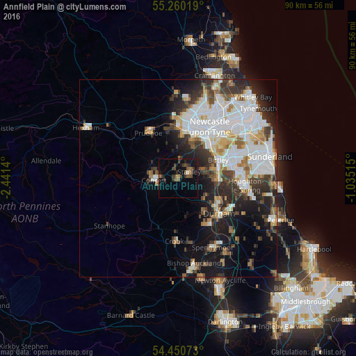
Analysis of Annfield Plain night lights 2016
Square area 10x10 km:
 0.36%
0.36%90-99
0.36%80-89
0%70-79
0.84%60-69
2.63%50-59
3.71%40-49
2.87%30-39
5.14%20-29
2.03%10-19
10.41%0-9
71.65%Square area 50x50 km:
7.25%90-99
5.11%80-89
1.82%70-79
1.91%60-69
2.28%50-59
2.22%40-49
2.22%30-39
4.14%20-29
5.18%10-19
8.51%0-9
59.37%Clear (daylight) street map image can be seen on geolist.org.
Map coordinates:
55° 15' 36.7" North, 2° 26' 29" West
54° 51' 27" North, 1° 44' 17.8" West
54° 27' 2.6" North, 1° 2' 6.5" West
Some cities around Annfield Plain sort by population:
• Chester-le-Street
10.5 km =6.5 mi,  89°
89°
• Consett
6 km =3.7 mi,  266°
266°
• Stanley
2.8 km =1.7 mi,  65°
65°
• Whickham
10.6 km =6.6 mi,  22°
22°
• Ushaw Moor
10.6 km =6.6 mi,  146°
146°
• Sacriston
8.5 km =5.3 mi,  121°
121°
• Rowlands Gill
6.9 km =4.3 mi,  356°
356°
• Pelton
8.4 km =5.2 mi,  78°
78°
2657282 (p: 10,406)
Sources (retrieved 2019-11-25):
» Earth at Night: Flat Maps 2012, 2016