Hedge End night lights from space
Night Light of Hedge End (England) from space (United Kingdom) Src. Average luminocity for 10x10km area is 37.8473% and for 50x50km: 13.2249%.
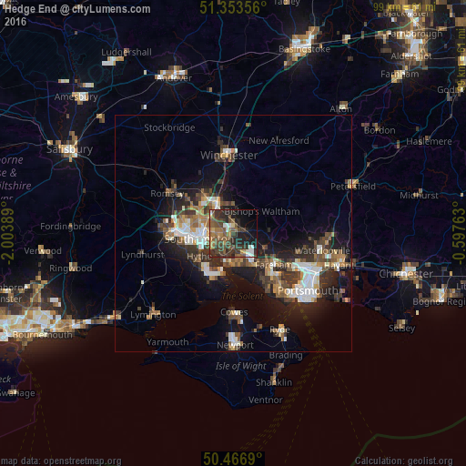
Analysis of Hedge End night lights 2016
Square area 10x10 km:
 2.52%
2.52%90-99
3.92%80-89
2.1%70-79
4.48%60-69
6.02%50-59
12.32%40-49
10.92%30-39
13.03%20-29
16.25%10-19
14.99%0-9
13.45%Square area 50x50 km:
1.79%90-99
2.23%80-89
0.88%70-79
1.25%60-69
1.81%50-59
2.13%40-49
2.48%30-39
3.02%20-29
4.11%10-19
8.85%0-9
71.44%Clear (daylight) street map image can be seen on geolist.org.
Map coordinates:
51° 21' 12.8" North, 2° 0' 14" West
50° 54' 44.4" North, 1° 18' 2.7" West
50° 28' 0.8" North, 0° 35' 51.5" West
Some cities around Hedge End sort by population:
• Southampton
7.3 km =4.5 mi,  262°
262°
• Fareham
10.9 km =6.8 mi,  128°
128°
• Eastleigh
7 km =4.3 mi,  330°
330°
• Hythe
9.2 km =5.7 mi,  230°
230°
• Bishopstoke
6.3 km =3.9 mi,  342°
342°
• Bursledon
3.1 km =1.9 mi,  200°
200°
• Netley
5.5 km =3.4 mi,  222°
222°
• Bishops Waltham
7.7 km =4.8 mi,  51°
51°
6620360 (p: 17,978)
Sources (retrieved 2019-11-25):
» Earth at Night: Flat Maps 2012, 2016