Bishopstoke night lights from space
Night Light of Bishopstoke (England) from space (United Kingdom) Src. Average luminocity for 10x10km area is 33.6415% and for 50x50km: 12.4734%.
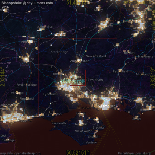
Analysis of Bishopstoke night lights 2016
Square area 10x10 km:
 2.24%
2.24%90-99
5.04%80-89
4.34%70-79
3.78%60-69
4.62%50-59
7.98%40-49
8.96%30-39
6.58%20-29
10.92%10-19
20.17%0-9
25.35%Square area 50x50 km:
1.73%90-99
2.12%80-89
0.83%70-79
1.14%60-69
1.7%50-59
1.99%40-49
2.35%30-39
2.87%20-29
4.05%10-19
8.34%0-9
72.87%Clear (daylight) street map image can be seen on geolist.org.
Map coordinates:
51° 24' 25.7" North, 2° 1' 53.2" West
50° 57' 59.1" North, 1° 19' 42" West
50° 31' 17.4" North, 0° 37' 30.7" West
Some cities around Bishopstoke sort by population:
• Southampton
8.8 km =5.5 mi,  217°
217°
• Eastleigh
1.5 km =0.9 mi,  271°
271°
• Winchester
11 km =6.8 mi,  3°
3°
• Hedge End
6.3 km =3.9 mi,  162°
162°
• Bursledon
8.9 km =5.5 mi,  174°
174°
• North Baddesley
8.3 km =5.2 mi,  278°
278°
• Netley
10.2 km =6.3 mi,  190°
190°
• Marchwood
12.3 km =7.6 mi,  225°
225°
2655557 (p: 17,667)
Sources (retrieved 2019-11-25):
» Earth at Night: Flat Maps 2012, 2016