Elm Park night lights from space
Night Light of Elm Park (England) from space (United Kingdom) Src. Average luminocity for 10x10km area is 79.9011% and for 50x50km: 53.3986%.
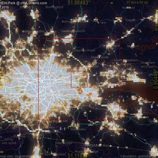
Analysis of Elm Park night lights 2016
Square area 10x10 km:
 19.79%
90-99
22.06%80-89
15.24%70-79
11.36%60-69
10.83%50-59
12.83%40-49
7.22%30-39
0.67%20-29
0%10-19
0%0-9
0%Square area 50x50 km:
20%90-99
11.72%80-89
5.52%70-79
4.49%60-69
4.59%50-59
4.44%40-49
4.6%30-39
5.27%20-29
9.4%10-19
13.43%0-9
16.54%Clear (daylight) street map image can be seen on geolist.org.
Map coordinates:
51° 59' 5.4" North, 0° 30' 6.3" West
51° 32' 58.9" North, 0° 12' 4.9" East
51° 6' 37.3" North, 0° 54' 16.2" East
Some cities around Elm Park sort by population:
• Dagenham
2.4 km =1.5 mi,  270°
270°
• Becontree
5 km =3.1 mi, 274°
• Romford
3 km =1.9 mi,  339°
339°
• Hornchurch
1.3 km =0.8 mi,  53°
53°
• Harold Wood
5.5 km =3.4 mi,  23°
23°
• Collier Row
6 km =3.7 mi, 335°
• Upminster
3.8 km =2.4 mi,  79°
79°
• Chadwell Heath
5.3 km =3.3 mi,  296°
296°
6690805 (p: 12,048)
Sources (retrieved 2019-11-25):
» Earth at Night: Flat Maps 2012, 2016