Downpatrick night lights from space
Night Light of Downpatrick (Northern Ireland) from space (United Kingdom) Src. Average luminocity for 10x10km area is 6.9875% and for 50x50km: 3.2535%.
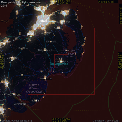
Analysis of Downpatrick night lights 2016
Square area 10x10 km:
 0.88%
0.88%90-99
0.63%80-89
0%70-79
2.01%60-69
2.01%50-59
2.01%40-49
0%30-39
0%20-29
0%10-19
0%0-9
92.48%Square area 50x50 km:
0.31%90-99
0.49%80-89
0.17%70-79
0.5%60-69
0.51%50-59
0.65%40-49
0.43%30-39
0.6%20-29
1.23%10-19
1.78%0-9
93.32%Clear (daylight) street map image can be seen on geolist.org.
Map coordinates:
54° 44' 10" North, 6° 25' 6.3" West
54° 19' 41.3" North, 5° 42' 55" West
53° 54' 57.9" North, 5° 0' 43.8" West
Some cities around Downpatrick sort by population:
• Lisburn
30 km =18.6 mi,  316°
316°
• Castlereagh
29.4 km =18.3 mi,  338°
338°
• Newtownards
29.4 km =18.3 mi,  3°
3°
• Dundonald
29.8 km =18.5 mi,  349°
349°
• Comber
24.7 km =15.3 mi,  355°
355°
• Carryduff
23.9 km =14.9 mi,  332°
332°
• Newcastle
16.7 km =10.4 mi,  222°
222°
• Ballynahinch
14.4 km =8.9 mi,  304°
304°
2651023 (p: 10,507)
Sources (retrieved 2019-11-25):
» Earth at Night: Flat Maps 2012, 2016