Comber night lights from space
Night Light of Comber (Northern Ireland) from space (United Kingdom) Src. Average luminocity for 10x10km area is 15.2907% and for 50x50km: 12.7787%.
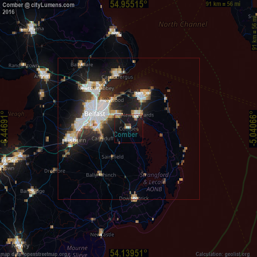
Analysis of Comber night lights 2016
Square area 10x10 km:
 1.79%
1.79%90-99
2.27%80-89
0.6%70-79
2.63%60-69
1.91%50-59
1.44%40-49
2.03%30-39
1.2%20-29
1.91%10-19
27.15%0-9
57.06%Square area 50x50 km:
2.83%90-99
2.85%80-89
0.81%70-79
1.32%60-69
1.21%50-59
1.42%40-49
1.33%30-39
1.78%20-29
3.65%10-19
8.49%0-9
74.31%Clear (daylight) street map image can be seen on geolist.org.
Map coordinates:
54° 57' 18.5" North, 6° 26' 48.9" West
54° 32' 57.7" North, 5° 44' 37.6" West
54° 8' 22.2" North, 5° 2' 26.4" West
Some cities around Comber sort by population:
• Belfast
12.8 km =8 mi,  294°
294°
• Newtownabbey
16.2 km =10.1 mi,  319°
319°
• Bangor
12.5 km =7.8 mi,  22°
22°
• Castlereagh
9.5 km =5.9 mi, 286°
• Newtownards
5.9 km =3.7 mi,  35°
35°
• Dundonald
5.9 km =3.7 mi, 323°
• Holywood
11.2 km =7 mi,  332°
332°
• Carryduff
9.9 km =6.2 mi,  249°
249°
2652505 (p: 9,190)
Sources (retrieved 2019-11-25):
» Earth at Night: Flat Maps 2012, 2016