Denbigh night lights from space
Night Light of Denbigh (Wales) from space (United Kingdom) Src. Average luminocity for 10x10km area is 2.3598% and for 50x50km: 6.1515%.
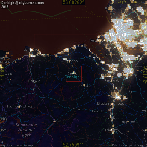
Analysis of Denbigh night lights 2016
Square area 10x10 km:
100  0%
0%
90-99 0%
80-89 0.51%
70-79 1.01%
60-69 0%
50-59 0.51%
40-49 0%
30-39 1.52%
20-29 0%
10-19 0%
0-9 96.46%
0%90-99
0%80-89
0.51%70-79
1.01%60-69
0%50-59
0.51%40-49
0%30-39
1.52%20-29
0%10-19
0%0-9
96.46%Square area 50x50 km:
100 0.71%
90-99 1.04%
80-89 0.48%
70-79 0.58%
60-69 0.83%
50-59 0.88%
40-49 0.99%
30-39 1.18%
20-29 1.37%
10-19 4.39%
0-9 87.56%
0.71%90-99
1.04%80-89
0.48%70-79
0.58%60-69
0.83%50-59
0.88%40-49
0.99%30-39
1.18%20-29
1.37%10-19
4.39%0-9
87.56%Clear (daylight) street map image can be seen on geolist.org.
Map coordinates:
53° 36' 9.4" North, 4° 7' 11.3" West
53° 10' 60" North, 3° 25' 0" West
52° 45' 35.7" North, 2° 42' 48.8" West
Some cities around Denbigh sort by population:
• Buckley
22.3 km =13.9 mi,  94°
94°
• Flint
20.1 km =12.5 mi,  70°
70°
• Rhyl
15.9 km =9.9 mi,  341°
341°
• Prestatyn
17.2 km =10.7 mi,  1°
1°
• Abergele
15.7 km =9.8 mi,  315°
315°
• Mold
18.4 km =11.4 mi,  95°
95°
• Holywell
16.1 km =10 mi,  50°
50°
• Ruthin
10.2 km =6.3 mi,  139°
139°
2651386 (p: 8,514)
Sources (retrieved 2019-11-25):
» Earth at Night: Flat Maps 2012, 2016