Codicote night lights from space
Night Light of Codicote (England) from space (United Kingdom) Src. Average luminocity for 10x10km area is 16.5842% and for 50x50km: 24.996%.
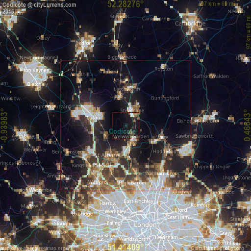
Analysis of Codicote night lights 2016
Square area 10x10 km:
 1.74%
1.74%90-99
1.87%80-89
0.67%70-79
0.53%60-69
1.34%50-59
4.68%40-49
2.54%30-39
1.47%20-29
2.27%10-19
36.63%0-9
46.26%Square area 50x50 km:
3.3%90-99
4.4%80-89
2.56%70-79
2.3%60-69
3.54%50-59
4.27%40-49
4.16%30-39
5.25%20-29
8.25%10-19
15.22%0-9
46.74%Clear (daylight) street map image can be seen on geolist.org.
Map coordinates:
52° 16' 57.9" North, 0° 56' 23.4" West
51° 51' 1.9" North, 0° 14' 12.1" West
51° 24' 50.7" North, 0° 27' 59.1" East
Some cities around Codicote sort by population:
• Luton
12.8 km =8 mi,  284°
284°
• Stevenage
6.2 km =3.9 mi,  22°
22°
• Welwyn Garden City
5.8 km =3.6 mi,  159°
159°
• Hatfield
9.7 km =6 mi,  174°
174°
• Hitchin
11.5 km =7.1 mi,  343°
343°
• Harpenden
9.1 km =5.7 mi,  245°
245°
• Hertford
12.5 km =7.8 mi,  119°
119°
• Redbourn
12.4 km =7.7 mi,  242°
242°
2652656 (p: 10,938)
Sources (retrieved 2019-11-25):
» Earth at Night: Flat Maps 2012, 2016