Clarkston night lights from space
Night Light of Clarkston (Scotland) from space (United Kingdom) Src. Average luminocity for 10x10km area is 72.2309% and for 50x50km: 30.0527%.
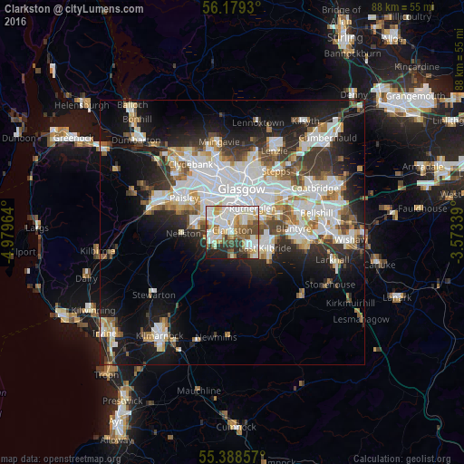
Analysis of Clarkston night lights 2016
Square area 10x10 km:
 20.69%
90-99
22.97%80-89
7.42%70-79
7.89%60-69
8.73%50-59
6.22%40-49
8.13%30-39
5.38%20-29
8.61%10-19
3.95%0-9
0%Square area 50x50 km:
8.23%90-99
7.53%80-89
2.24%70-79
2.9%60-69
3.08%50-59
2.81%40-49
3.06%30-39
3.8%20-29
6.2%10-19
13.21%0-9
46.96%Clear (daylight) street map image can be seen on geolist.org.
Map coordinates:
56° 10' 45.5" North, 4° 58' 46.7" West
55° 47' 9.4" North, 4° 16' 35.4" West
55° 23' 18.9" North, 3° 34' 24.2" West
Some cities around Clarkston sort by population:
• Glasgow
8.9 km =5.5 mi,  7°
7°
• East Kilbride
6.7 km =4.2 mi,  111°
111°
• Rutherglen
6.2 km =3.9 mi,  39°
39°
• Cambuslang
7.7 km =4.8 mi,  69°
69°
• Newton Mearns
3.8 km =2.4 mi,  248°
248°
• Barrhead
7.4 km =4.6 mi,  281°
281°
• Giffnock
2.3 km =1.4 mi,  329°
329°
• Neilston
9.4 km =5.8 mi,  269°
269°
6640069 (p: 9,460)
Sources (retrieved 2019-11-25):
» Earth at Night: Flat Maps 2012, 2016