Cheddar night lights from space
Night Light of Cheddar (England) from space (United Kingdom) Src. Average luminocity for 10x10km area is 1.2115% and for 50x50km: 9.7413%.
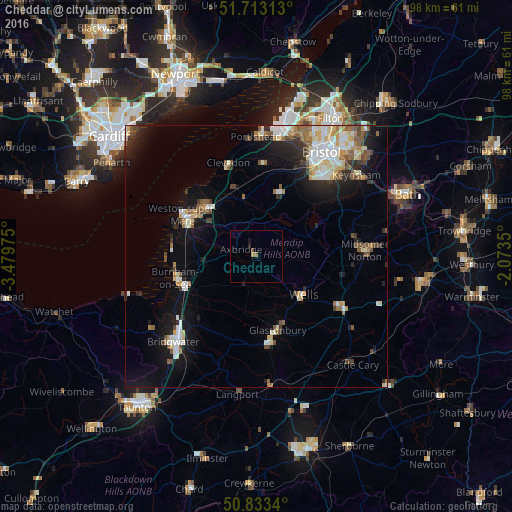
Analysis of Cheddar night lights 2016
Square area 10x10 km:
 0%
0%90-99
0%80-89
0%70-79
0.14%60-69
0.84%50-59
0.14%40-49
0.56%30-39
0%20-29
0.56%10-19
0.56%0-9
97.2%Square area 50x50 km:
1.56%90-99
1.91%80-89
1.07%70-79
0.89%60-69
1.03%50-59
1.43%40-49
1.29%30-39
0.95%20-29
2.04%10-19
6.01%0-9
81.82%Clear (daylight) street map image can be seen on geolist.org.
Map coordinates:
51° 42' 47.3" North, 3° 28' 47.1" West
51° 16' 31.3" North, 2° 46' 35.8" West
50° 50' 0.2" North, 2° 4' 24.6" West
Some cities around Cheddar sort by population:
• Mendip
11.3 km =7 mi,  112°
112°
• Weston-super-Mare
16 km =9.9 mi,  299°
299°
• Burnham-on-Sea
15.9 km =9.9 mi,  255°
255°
• Nailsea
17.5 km =10.9 mi,  4°
4°
• Street
16.9 km =10.5 mi,  171°
171°
• Wells
11.6 km =7.2 mi,  130°
130°
• Yatton
13 km =8.1 mi,  345°
345°
• Glastonbury
14.7 km =9.1 mi,  164°
164°
2653281 (p: 5,199)
Sources (retrieved 2019-11-25):
» Earth at Night: Flat Maps 2012, 2016