Carshalton night lights from space
Night Light of Carshalton (England) from space (United Kingdom) Src. Average luminocity for 10x10km area is 85.5% and for 50x50km: 56.2712%.
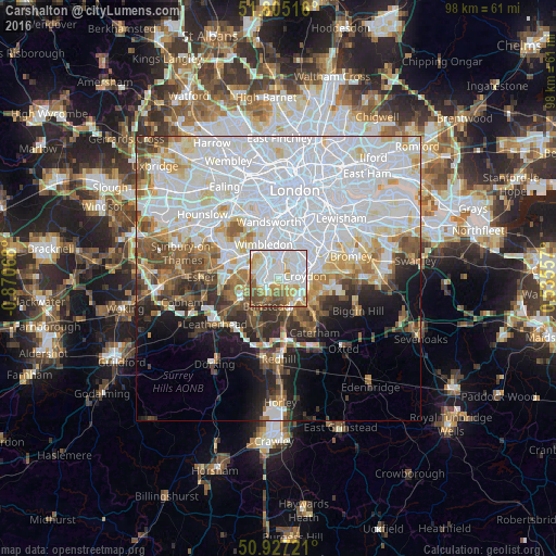

Analysis of Carshalton night lights 2016
Square area 10x10 km:
 35.15%
90-99
20.87%80-89
11.76%70-79
11.62%60-69
6.16%50-59
9.8%40-49
4.48%30-39
0.14%20-29
0%10-19
0%0-9
0%Square area 50x50 km:
25.14%90-99
13.31%80-89
4.75%70-79
4.23%60-69
4.49%50-59
4.29%40-49
4.38%30-39
3.7%20-29
4.55%10-19
6.71%0-9
24.45%Clear (daylight) street map image can be seen on geolist.org.
Map coordinates:
51° 48' 18.6" North, 0° 52' 14.4" West
51° 22' 5.8" North, 0° 10' 3.2" West
50° 55' 38" North, 0° 32' 8.1" East
Some cities around Carshalton sort by population:
• Sutton
3 km =1.9 mi,  227°
227°
• Croydon
5 km =3.1 mi,  70°
70°
• Purley
5.2 km =3.2 mi,  132°
132°
• South Croydon
5.1 km =3.2 mi,  97°
97°
• Mitcham
3.9 km =2.4 mi,  359°
359°
• Morden
4 km =2.5 mi,  327°
327°
• Worcester Park
5.5 km =3.4 mi,  283°
283°
• Cheam
3.7 km =2.3 mi,  258°
258°
2653646 (p: 45,525)
Sources (retrieved 2019-11-25):
» Earth at Night: Flat Maps 2012, 2016